Geotab Navigation
Commercial vehicles face routing challenges that ordinary navigation apps are not designed to handle. Geotab Navigation provides turn-by-turn guidance based on vehicle dimensions, cargo requirements, road restrictions, and other operating considerations. Integrated with Geotab Drive, it helps fleets plan safer, more predictable trips while giving drivers a connected navigation experience.
Truck-Safe Routes for Commercial Vehicles
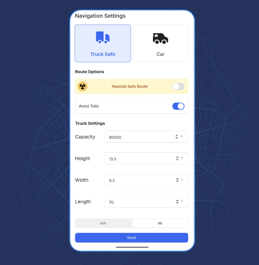
Geotab Navigation calculates routes using vehicle-specific information such as height, weight, width, length, and cargo type. By directing drivers toward roads that are more appropriate for their vehicles, the solution can help fleets reduce unsuitable road selections, unexpected detours, bridge-clearance concerns, and schedule disruptions.

Support Safer and More Compliant Trips
Commercial restrictions are considered before a route is generated. Geotab Navigation can account for weight limits, hazardous-material requirements, truck-prohibited roads, and toll preferences, helping drivers avoid restricted areas and supporting more consistent compliance with vehicle and roadway requirements.
Identify Higher-Risk Roads in Advance
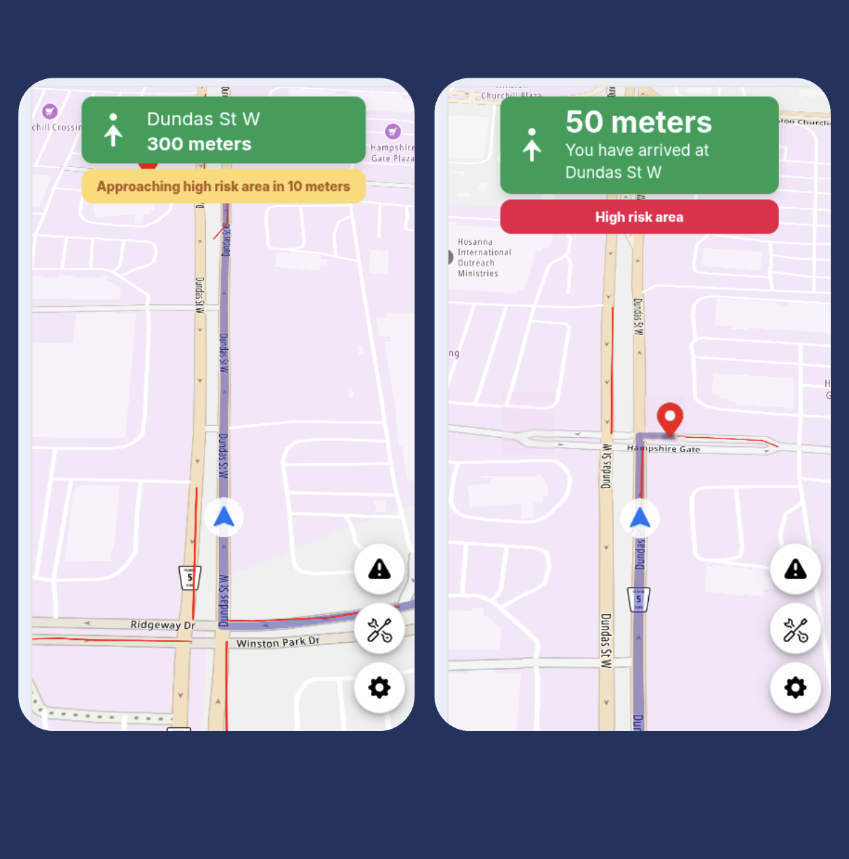
Geotab Navigation uses aggregated insights from millions of fleet trips to identify road segments associated with elevated driving risk. Drivers can receive advance warnings before reaching these areas, giving them more time to prepare, adjust their driving, and approach challenging road conditions with greater awareness.

Keep Drivers in One Connected Application
Navigation is built directly into Geotab Drive alongside driver vehicle inspection reports, hours-of-service tools, messaging, and other fleet workflows. Drivers can access route guidance and essential work tools through one application, reducing unnecessary app switching and creating a simpler experience throughout the workday.
Scale Beyond Turn-by-Turn Navigation
Fleets can begin with commercial navigation and expand into Geotab’s Advanced Routing & Optimization suite as their operational needs grow. This provides a path toward connected route planning, dispatching, stop sequencing, and fleet-wide optimization without moving to an entirely separate platform.
Bring Greater Confidence to Every Route
Help your drivers reach their destinations using routes designed for the realities of commercial fleet operations. As a Geotab reseller, GPS Tracking America can help you evaluate Geotab Navigation and determine how it can support your drivers and fleet. Contact us today to learn more and get started.
What is Geotab Navigation?
Geotab Navigation is a commercial navigation solution that provides turn-by-turn directions based on vehicle dimensions, weight, cargo, and applicable road restrictions. It is integrated with Geotab Drive to create a connected experience for commercial drivers.
How is Geotab Navigation different from a consumer navigation app?
Consumer navigation apps typically calculate routes for passenger vehicles. Geotab Navigation considers commercial vehicle characteristics and restrictions, helping drivers avoid roads, bridges, and other areas that may be unsuitable for their vehicles.
How does Geotab Navigation calculate commercial vehicle routes?
The navigation uses vehicle-specific information, road data, and applicable restrictions to calculate suitable routes. Factors can include vehicle height, weight, width, length, cargo type, and road access rules.
Can Geotab Navigation account for vehicle height?
Yes. Vehicle height can be considered when calculating a route, helping drivers avoid bridges, tunnels, and other locations with insufficient clearance.
Does Geotab Navigation consider vehicle weight?
Yes. The solution can use vehicle weight information to help drivers avoid roads and bridges with weight restrictions that may apply to their vehicles.
Can Geotab Navigation account for vehicle width and length?
Yes. Vehicle width and length can be included in the routing profile so that the recommended route is better suited to the physical size of the commercial vehicle.
Does Geotab Navigation support hazardous-material routing?
It can consider hazardous-material restrictions when calculating routes. This helps direct drivers away from roads, tunnels, and other areas where their cargo may be restricted.
Can Geotab Navigation avoid truck-restricted roads?
Yes. it can recognize roads where commercial trucks are prohibited or restricted and use that information when calculating a route.
Can drivers choose whether to use toll roads?
The navigation can account for toll-road preferences when creating routes. Fleets can use this capability to better align navigation with their operating priorities and travel policies.
Does Geotab Navigation provide turn-by-turn directions?
Yes. Drivers receive turn-by-turn route guidance designed for commercial fleet operations, helping them navigate from their current location to assigned destinations.
Is Geotab Navigation integrated with Geotab Drive?
Yes. The navigation is integrated directly with Geotab Drive, allowing drivers to access navigation alongside other tools used during their workday.
What other tools can drivers access through Geotab Drive?
Depending on the fleet’s setup and subscriptions, Geotab Drive can provide access to hours-of-service tools, driver vehicle inspection reports, messaging, workflows, and other fleet applications.
How can Geotab Navigation reduce app switching?
Because navigation is available within Geotab Drive, drivers can access directions and other work-related tools through one connected application. This creates a simpler workflow and reduces the need to move between separate apps.
What are predictive road-risk alerts?
Predictive road-risk alerts notify drivers before they approach road segments associated with elevated driving risk. These insights are based on aggregated information from millions of fleet trips.
How can predictive road-risk alerts help drivers?
Advance warnings give drivers more time to prepare for potentially challenging road segments. This can support greater awareness and encourage drivers to adjust their speed or driving behavior as appropriate.
Can Geotab Navigation help fleets avoid unnecessary detours?
By calculating routes using commercial vehicle information and road restrictions, Geotab Navigation can help reduce unsuitable route choices that may otherwise lead to unexpected detours, delays, or difficult turnarounds.
Can Geotab Navigation help fleets support compliance?
The navigation considers relevant commercial road restrictions when calculating routes. This can support compliance efforts, but drivers and fleet operators remain responsible for following posted signs, laws, regulations, and company policies.
What types of fleets can benefit from Geotab Navigation?
The solution may benefit trucking, delivery, construction, field service, utility, transportation, and other fleets that operate commercial vehicles with specific routing requirements.
Can Geotab Navigation support broader route optimization?
Yes. Fleets can combine commercial navigation with Geotab’s Advanced Routing & Optimization capabilities to support functions such as route planning, stop sequencing, dispatching, and operational optimization.
How can GPS Tracking America help with Geotab Navigation?
As a Geotab reseller, GPS Tracking America can help your business evaluate Geotab Navigation, review fleet requirements, select an appropriate solution, and support implementation. Contact us to learn how commercial navigation can fit into your fleet operations.